Morocco’s best valleys and oases to explore: Draa valley, Todra gorge, and beyond
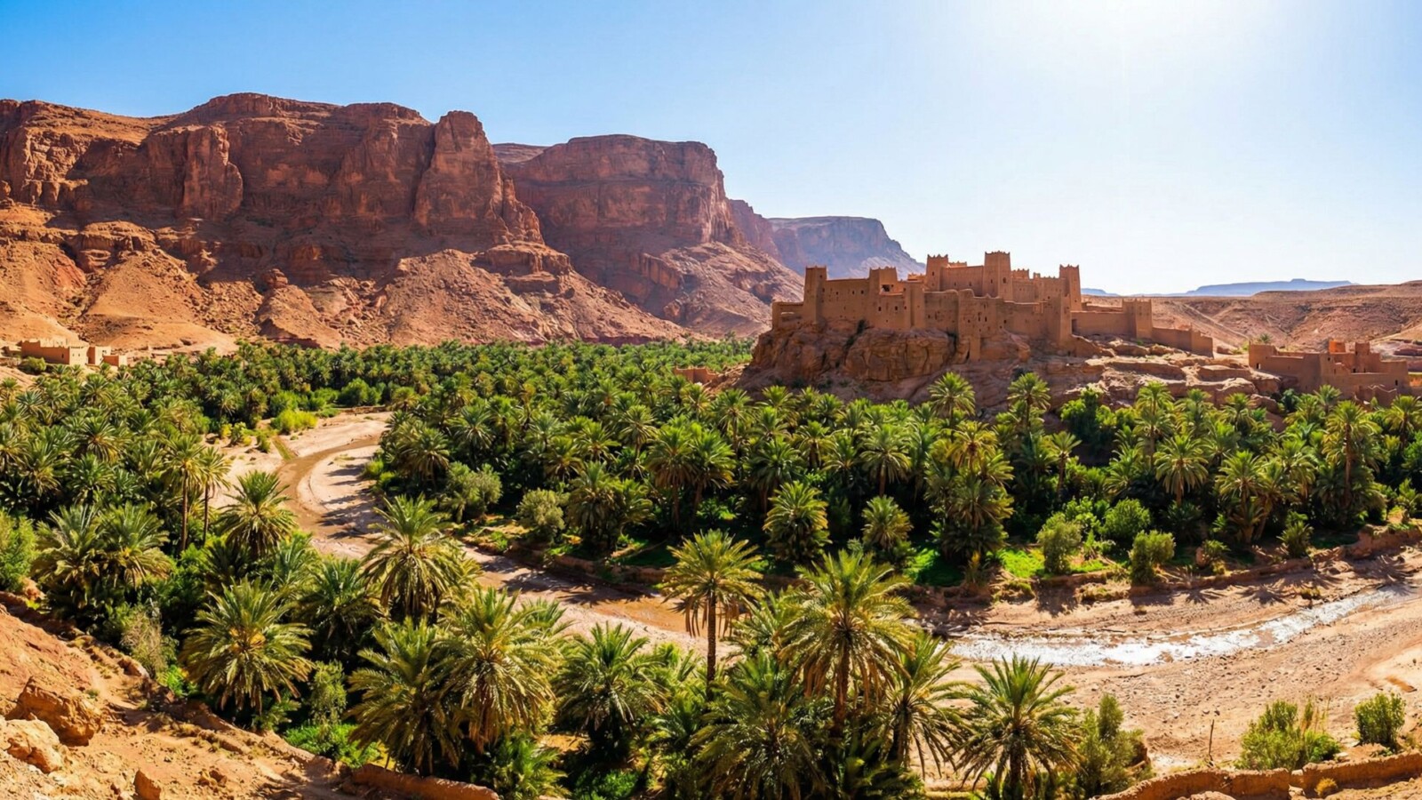
Discover the dramatic gorges, palm-lined river valleys, and lush oases that cut through Morocco’s arid landscapes, including the Draa Valley, Todra Gorge, and the Date Route.
Between the Atlas Mountains and the Sahara Desert lies some of Morocco’s most unexpected scenery, river valleys carved deep into red rock, and oases where date palms rise against a backdrop of barren cliffs. These pockets of green have sustained travelers and traders for centuries, and today they offer a striking counterpoint to the more famous dunes and medinas. To truly appreciate how these fertile zones exist amid such arid surroundings, it helps to explore the full picture of Morocco’s geography and the water systems that make life possible here.
The Draa Valley: Morocco’s longest river
The Draa River stretches roughly 700 miles from its source in the High Atlas to its theoretical endpoint at the Atlantic Ocean, though water rarely makes it that far these days. What matters for travelers is the 125-mile stretch between Agdz and Zagora, where the river creates Morocco’s most spectacular palm oasis.
Driving this route feels like traveling through time. Ancient kasbahs built from packed earth rise above the palm groves, their crenellated towers silhouetted against impossibly blue skies. The road follows the river closely, winding past villages where life has changed little over generations. Donkeys carry loads through narrow lanes. Farmers tend date palms and vegetable plots. Children wave at passing cars with genuine enthusiasm rather than practiced tourist interactions.
The town of Agdz marks the northern gateway to the valley and makes a logical first stop. The kasbah here offers views across the palmeraie, and several small hotels provide a comfortable base for exploration. From Agdz, the road south passes through a series of oasis villages, each with its own distinct character.
Tamnougalt is worth a detour for its remarkably preserved kasbah complex. Families still live within these ancient walls, and wandering the labyrinthine passages gives a sense of what Moroccan desert architecture looked like before concrete took over. The village also sits at the intersection of several old caravan routes, a reminder of the Draa Valley’s importance to trans-Saharan trade.
Zagora serves as the valley’s main town and the endpoint for most visitors. The famous sign declaring “Timbuktu 52 Days” by camel caravan captures the imagination, even if nobody is actually making that journey anymore. The town itself is functional rather than charming, but it provides services and serves as a launching point for desert excursions. Many travelers use Zagora as a base for visiting the dunes of Erg Chigaga.
Beyond Zagora, the road continues to M’Hamid through increasingly sparse scenery. The palms thin out, the villages become smaller, and the desert begins asserting itself. This final stretch rewards travelers heading to the remote dunes with a gradual transition from green to sand.
Todra Gorge: vertical drama
If the Draa Valley impresses with its horizontal sprawl, Todra Gorge delivers vertical shock. This narrow canyon northeast of Tinghir squeezes between limestone cliffs that rise 1,000 feet on either side. At the narrowest point, the walls stand just 30 feet apart while towering overhead. The scale defies photography.
The drive to Todra Gorge passes through the Todra Oasis, 15 miles of palm groves fed by the river that carved the canyon. Pink mud-brick villages cluster along the water’s edge, and the contrast between lush green palms and bare rocky hillsides never gets old. This stretch is best experienced slowly, with stops to explore villages and watch daily life unfold.
The gorge itself has become a rock climbing destination with international recognition. The smooth limestone walls offer routes for all skill levels, and climbers from around the world make pilgrimages here during the cooler months. Even if climbing isn’t your thing, watching skilled practitioners dance up vertical faces adds drama to the landscape.
For non-climbers, the gorge offers excellent hiking. A well-maintained path follows the canyon floor, crossing the shallow river multiple times. The walk takes just an hour or two but rewards with constantly changing perspectives on the towering walls. Morning light is best, when the sun illuminates the upper cliffs in shades of gold and orange.
Several small hotels and cafes cluster at the gorge entrance, making it possible to spend the night and experience the canyon at different times of day. Sunrise and sunset transform the colors dramatically. Staying overnight also means you can explore after the day-tripping crowds have departed.
The broader Tinghir area deserves more attention than most travelers give it. The town itself has an excellent medina, far less touristy than Fes or Marrakech but with similar architectural charm. The palmeries surrounding Tinghir rival those of the Draa Valley in beauty if not in length. Spending a few days here rather than just passing through reveals layers that a quick gorge visit misses.
Dades Valley and Dades Gorge
Running roughly parallel to Todra about 25 miles to the west, the Dades Valley offers a different character despite superficial similarities. The gorge here is wider and longer, with rock formations that seem almost sculptural. Strange pillared shapes known locally as the “Monkey Fingers” rise from the valley floor, twisted by millions of years of erosion into forms that seem almost deliberate.
The road through Dades Gorge is an attraction in itself. A series of aggressive switchbacks known as the “Dades Gorge hairpin turns” or just “the serpentine” winds up the canyon wall in a feat of engineering that seems reckless and thrilling in equal measure. The views from the top justify the white-knuckle driving, assuming you can take your eyes off the road.
The town of Boumalne Dades anchors the valley and provides more services than Tinghir. From here, the road climbs into the gorge proper, passing kasbahs and small villages for about 40 miles before eventually reaching the High Atlas plateau. Most travelers explore only the lower section, but those with time and a decent vehicle can continue into genuinely remote territory.
The Dades Valley also marks the beginning of the “Road of a Thousand Kasbahs,” a romantic name for the route connecting Ouarzazate to Errachidia through some of Morocco’s most dramatic scenery. These fortified mud-brick structures once served as homes, granaries, and defensive positions for Berber families. Today they range from crumbling ruins to lovingly restored guesthouses.
Rose season in May brings something special to the Dades Valley. The town of Kelaat M’Gouna hosts an annual rose festival celebrating the damask roses grown throughout the region. The blooms supply a significant portion of the world’s rose water and rose oil production. Fields of pink flowers against red rock backgrounds create images almost too pretty to believe.
The Ziz Valley and Tafilalet Oasis
East of the Todra and Dades lies the Ziz Valley, less visited but equally impressive. The Ziz River carves a canyon through the High Atlas before spreading into the Tafilalet plain, creating one of Morocco’s largest oasis systems. The city of Errachidia serves as the regional hub, though most travelers pass through quickly on their way to Merzouga and the Sahara.
The drive through the Ziz Gorge offers some of Morocco’s most dramatic roadside scenery. Tunnels punch through solid rock. Overlooks provide views of the river winding far below. Date palms carpet the canyon floor in impossible green. The Legionnaire’s Tunnel, built by the French Foreign Legion in the 1920s, remains an engineering marvel that hints at the strategic importance of controlling this route.
Erfoud anchors the southern end of the Tafilalet and claims fame for two unexpected things: fossils and dates. The surrounding desert contains rich deposits of marine fossils from when this region lay beneath an ancient sea. Workshops in town turn these fossils into decorative items ranging from tasteful to tacky. The annual date festival in October celebrates the harvest with music, competitions, and more dates than you could eat in a lifetime.
Rissani lies just south of Erfoud and holds deep historical significance. This was the original capital of the Alaouite dynasty that still rules Morocco today. The mausoleum of Moulay Ali Cherif, ancestor of the current king, draws pilgrims from across the country. The town’s souk is one of Morocco’s most authentic, particularly lively on market days when traders from surrounding villages converge.
The Ait Bougmez Valley: happy valley
Tucked into the High Atlas northwest of the major gorge systems, the Ait Bougmez Valley earns its nickname through a combination of fertile land, welcoming villages, and scenery that seems almost Alpine. This is trekking country rather than road-trip territory, though a paved road now provides access that was impossible a generation ago.
The valley stretches roughly 20 miles between mountains that top 10,000 feet on both sides. Traditional stone and mud-brick villages cluster on the slopes, surrounded by terraced fields of wheat, barley, and vegetables. Walnut and apple orchards fill the gaps between farms. The overall impression is of abundance in a country where arable land is precious.
Trekkers use Ait Bougmez as a base for accessing the M’Goun massif, one of Morocco’s premier hiking destinations. Multi-day routes cross high passes with views extending to the Sahara. The infrastructure for trekking is well-developed, with local guides, mule support, and village guesthouses along the main routes.
Even without ambitious trekking plans, the valley rewards a few days of exploration. Walking between villages takes you through working agricultural landscapes where farming methods haven’t changed dramatically in centuries. The pace of life here is slow by necessity, tied to seasons and harvests rather than modern schedules.
Getting to Ait Bougmez requires commitment. The most common approach follows a mountain road from Azilal, winding through increasingly dramatic scenery for about 60 miles. The road is paved but narrow, with steep drops and no guardrails in places. The journey takes several hours and demands attention, but the destination justifies the effort.
Practical advice for valley exploration
These valleys reward travelers who take their time. Rushing through on a packed itinerary means missing the subtleties that make each place special. Plan for at least two or three days if you want to explore properly, more if you intend to hike or photograph seriously.
Renting a car provides the most flexibility for valley exploration. Roads are generally good, though some sections in the gorges require careful driving. A standard vehicle handles most routes fine, though high clearance helps on rougher tracks. Driving yourself also allows stops wherever the view demands it, which happens frequently.
Guided day trips from Marrakech or Ouarzazate offer an alternative for those uncomfortable driving mountain roads. These typically cover the main highlights of Dades and Todra gorges in a long day. The convenience comes at the cost of flexibility and depth, but it’s better than skipping the valleys entirely.
Accommodations range from simple village guesthouses to beautifully restored kasbahs with swimming pools and mountain views. Staying in traditional settings adds immeasurably to the experience. Waking up to the call to prayer echoing off canyon walls, sharing breakfast with families who have lived in these valleys for generations, these moments define Morocco travel more than any famous monument.
The valleys and oases represent Morocco at its most photogenic and least hyped. They connect the famous destinations – Marrakech to Fes, mountains to desert – while offering experiences that stand entirely on their own merit. Any serious Morocco itinerary should include at least one of these green ribbons threading through the red rock landscape.
For travelers interested in understanding how these fertile zones exist amid such harsh terrain, exploring Morocco’s varied climate patterns reveals the seasonal rhythms that bring water to these valleys and sustain the communities that call them home.